


NEWS
“Live” Story Map Site Details Actions Taken to Remediate Asbestos

The “Story Map” Davidson Community Asbestos site was frequently cited as great resource for information. [screen shot]
Wednesday, January 27, the Environmental Protection Agency, the N.C. Department of Environmental Quality’s (NCDEQ) Division of Waste Management, and the Town of Davidson co-hosted the third virtual-meeting in an ongoing series of public discussions about asbestos removal efforts in the town. This event and previous sessions provided opportunities for members of the community to discuss asbestos-contaminated soil removal activities following recent expanded soil sampling for asbestos within one-quarter mile of the former Carolina Asbestos Corporation site – known as the Linden Mill.
The entire meeting can be viewed on the Town’s YouTube channel at this link. Your News of Davidson team felt that it was important announce the meeting in advance and to provide a summary, as well as a transcript of the extended Q&A session.
Members of the community were able to send in questions in advance or real time via chat and text as the meeting took place. Angela Miller, the EPA Community Involvement Coordinator for this project, was the primary presenter and virtual moderator for the meeting. She was joined by four additional members of the EPA staff, a representative from NCDEQ, and Doug Wright from the Town of Davidson. Contact information for all the participants is at the end of this article.
All of the participants relied on the “Story Map” developed by the EPA and NCDEQ to answer many of the questions. It was described as the most comprehensive resource, by far, regarding the former asbestos mill in Davidson.
At the outset of the meeting, they reviewed the work in 2016/2017 – which included taking 323 soil samples from 93 areas/parcels. The breakout of details from those samples were as follows:
- 257 samples no asbestos detected
- 50 traces of asbestos detected
- 18 0.25-1% asbestos in the sample
- 7 greater than 1%
- 17 bulk asbestos-containing material
As a result of those findings, the EPA excavated 32 properties – and removed 6,204 tons of soil. Essentially the top layer of soil 3-6” was removed, with deeper efforts if asbestos was visible. Orange “snow fence” was placed at the depth of the remediation, and clean fill dirt was then placed on top of that. In some areas sod was the final top cover, and gravel in other areas – all depending on the property owners’ requests.
Because the danger associated with asbestos is when the fibers are disturbed and become airborne and potentially inhaled, a number of precautions were taken. Most notably, the EPA offered residents the opportunity to temporarily relocate to a hotel when the work was being done on their property. Workers donned Tyvek suits and wore respirators. Additionally, air monitors were placed around the edges of the property to detect any airborne traces of asbestos.
Miller noted several times during her presentation, that property owners must give authorization for the EPA to take the test samples on their property. All properties where the EPA was given access were tested. While there were a number of property owners who did not respond to requests for access for sampling, only one property owner refused access to his property.
In 2020, the EPA returned to town to sample additional properties from a larger area around the former mill. Despite the constraints of necessary COVID precautions, workers took 521 soil samples from 136 parcels. Of those, 125 parcels require no further action. Eleven properties require EPA removal action, and 5 of them required interim mitigation measures.
The removal action for those 11 properties will be starting in the coming weeks. That work includes two areas within Roosevelt Wilson Park. The park will be closed while the excavation work takes place, and air monitoring will be put in place. An additional mitigation measure taken during the process is that water is used to dampen the soil and limit the potential for particles to become airborne. The combination of the site preparation work and the excavation/removal work is expected to take between 6-8 weeks, weather permitting.
EPA and NCDEQ representatives also continued to reinforce the call for any property owners who have not provided access for asbestos sampling to please do so. “We have to have permission to access your property before we can do any sampling,” Miller said.
Questions during the session included:
(Of note, at times there was additional cross-talk after an answer was given. Unless the material was new and informative – that additional content was not included in the following transcript.)
Q: I noticed one parcel that was denied access (location mentioned was incorrect).
A: (Angela Miller) They just didn’t want us to sample, and we can’t make them. It’s their property. We can try. And when I’m out there this time, I’ll try to talk to her again. But we can’t make people give us access.
Q: Has EPA/TetraTech (contractor) identified a location where they will be mobilizing for energy removal activities, i.e. staging activities?
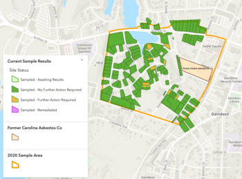
This screen shot from the Story Maps site shows the map that reflects all the properties that have been tested in this round of sampling. Green reflects properties that require no further action. The orange properties require action, and will be remediated in the next few months.
A: (Chris Tripp) I was actually here today with the EPA contractor looking into which area/property we are going to use for staging the asbestos contaminated soils and any other equipment. The one we looked at today – I don’t think that’s going to quite work out. We are looking at two other properties. We are looking at that now, working with the property owner. I was hoping to have something secured. And that is something that rolls into another question.
Q. When are you (EPA and contractor) going to mobilize?
A. (Chris Tripp) I was hoping to have that property secured and worked out with the property owner so that we could even get going next week. I just don’t know how promising that was in that we didn’t make any progress on that today, unfortunately.
Q. Funds?
A. (Chris Tripp) Yes, we are okay on funds. That’s already been worked out. Back in November, that was already signed off on by the Superfund Emergency Management Division Director. So those funds are in place.
Q. ?(Question was not read aloud)
A. (Chris Tripp) Charlotte Water – we are working in coordination with them. Where they have something going on we will work around. . .we just plan to work with one another. Not cause either Charlotte Water or EPA to have to delay their activities. We are just going to coordinate and work with one another on that.
Q. Will the removal activities impact the proposed redevelopment of the former asbestos mill that is proposed?
A. (Chris Tripp) It won’t impact what is going on at that property. That is separate from the EPA removal work. That won’t impact the Brownfields effort.
(Angela Miller) That project is with the North Carolina Department of Environmental Quality – Carolyn. (who is helping answer the text questions and is not on the video as a panelist) We can get you a better answer. If you want more information about the Brownfields we can certainly get that to you.
(Miguel Alvalle) Agree. This is not going to impact that.
Q. Can I see an enlarged view of the map with the green, yellow, and gold markings?
A. (Chris Tripp) You can access all those maps at the story map site, just google it. Everybody can access that. It is a live map.
(Angela Miller) It is a great resource. Chris put a lot of work into it, and when we remediate properties, that map will change. So, like Chris said – it is a live map. And if we sample more properties, that color will change and you will be able to see those changes.
(Chris Tripp) I also want to give a shout out to North Carolina DEQ – they put a lot of work into that map too.
Q. Do you feel that more properties have agreed to be sampled since the last public input session?
A. (Angela) I will say that these virtual meetings have helped us to obtain access – yes. Not sure we had any additional properties since the last meeting in December, but these virtual meetings have helped us significantly. Because you know we have had the challenge of having to obtain permission for access while everything was shut down. But I think we did pretty well considering the challenges. But again, if you know a property owner – all they have to do is contact me and we are willing to sample while we are out there.
Q. What are the streets that were impacted? Or where is the cleanup going?
A. (Angela) Let me get back to the map. (Chris) Mock Road, Potts Street, Crane Street, Brandon, the park area (Roosevelt Wilson), and Mock Circle. Those are the areas where folks are likely to see work and trucks.
Q. I was struck by the amount of yellow, of properties not tested. Is there a risk that these are contaminated, and that asbestos can leech into other properties?
A. (Chris Tripp initially notes that the brighter yellow color on the map is reflective of work done in 2016/17 and refers folks to the newer map available in story maps) As far as “leeching,” that is not likely. The main way for something like that to take place is the material that was at the surface, over time disturbing that – disturbance activities – like cutting grass. But more extensive issue is more disturbance of the soil. Tim (Frederick) do you want to add to that – with regards to migration of the asbestos onto other properties.
(Tim Frederick) Sure, the main concern here is (and this is kind of addressing some of the other questions, as well) the source of this material is not primarily from blowing off of other properties – specifically the former plant area. It is waste material (from the plant) that has been used as fill in yards. So, we see the material that was transported over there – and we see it in some yards, but not others. And why it seems that there isn’t too much of a rhyme or reason for it. One of the questions that we seem to be focused on:
Q. Why are we focused on this small area?
A. The reason we are focused on this area is because of the proximity to the former mill. And people who lived closer to that mill, at the time, to go get that – use that – as fill material. Folks from further away don’t seem to have, or got fill material from other places. They didn’t get it from the mill. That seems to have been borne out by our sampling. As we move farther away from the mill we are seeing less of the material in those yards.
Q. Will you guys be offering testing inside the home?
A. (Chris Tripp) No, we don’t do any testing or sampling inside the home. The way that our authority is drawn together is that if there is a release or threat to release into the environment. So, unless there was some real threat that there would be released outside of the home. There is the issue that if there is a small amount in the home – whether it came from the yard – or whether it was something else that was inside the home – because there were products inside the home that have it. So, that’s just not something that we (EPA) do.
(Tim Frederick) The amount that would be inside – the waste material in the yards is the main source, and that’s what we are after. If you are concerned about things that were tracked inside – it is the material that is in the soil that is the issue. If there’s not a lot of dirt that comes into the home on shoes are by pets, or dust that is blown in when windows are open – there’s probably not a lot that’s inside there. Basic housecleaning can reduce the amount if that material is present in the yard.
(Miquel Alvalle) You can always reach out to the North Carolina Department of Health and they can refer you to some guidance about things you can do to limit stuff being tracked into the house.
Q. Will the cleanup impact Lake Davidson at all?
A. (Chris Tripp) It shouldn’t impact Lake Davidson so much. It will impact the park (Roosevelt Wilson) area. Just in those couple of spots where we plan on doing some soil excavation, removal there. But as far as impacting the lake, there won’t be any impacts.
Q. Another question about the creek next to the park.
A. There are a couple of things to point out. (1) It’s the asbestos in the air that’s the issue. So, if there were any asbestos in the creeks or lake, it would be submerged/underwater – so there would be no risk, because it is not there for people to breathe. (2) In 2017, in our initial effort we did sample the sediments in the lake and I think in the adjacent creek heading toward the park – and we didn’t see anything in the sediments.
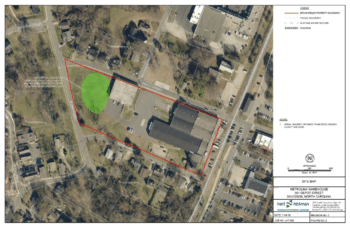
This is the aerial image of the former Carolina Asbestos Mill on Depot Street. The green spot shows the area that was pit/pile of asbestos contaminated products.
Q. The area of current sampling looks pretty tightly contained. What led to that area being sampled? Is there a need to expand the sampling to see if there is a wider ranging contamination?
A. (Angela) So when we first started sampling, we sampled the properties right there at the former mill. And just as we expected, there was more contamination there. We expanded the sampling. First, what got us started was community concerns. That’s what led to DEQ calling out EPA to do an assessment. So, our expectations were correct in that there was contamination around the mill. The community was still concerned, so we expanded the sampling. The good news is that we have not found nearly the contamination we found in 2017. We had 32 properties (that needed remediation) back then, and this time we only have 11.
(Miguel Alvalle) If you look at the data, if you look at the map, the properties that require remediation this time are still fairly close to the mill property. As we get farther West we are not seeing it. As we get further North, we aren’t seeing it. We do have the one outlier – the one property on Potts Street. But, we try to expand it and see what we can see – and then create a boundary of where we don’t see it anymore. We are using the data we have to create that boundary.
(Chris Tripp) The one outlying property was one that there was historical information about the property owner bringing in soil/fill from in town. And so we tested it, and we tested it. And it turned out that just the front yard tested positive with a small amount. But it met the criteria for removal.
Q. When replacing the asphalt driveway at the church (Davidson Presbyterian Church) – why didn’t the church get an asphalt driveway instead of gravel?
A. (Angela) From what I remember, they didn’t want it. They wanted gravel. They were going to be expanding/developing the area and that’s what they wanted.
(Miguel) And I believe there was a specific request for a type of gravel, and that was done.
Q. Why weren’t these locations taken care of with the excavations done several year ago?
A. (Miguel Alvalle) Either there was no access given or the information was not available at that time. Or the current resident (now) was not – properties have changed hands. We opened the sampling the last time to anyone who wanted to get sampled in that general area. And everyone who wanted to get sampled, did get sampled. A lot of it was people who did not want to get sampled, or the people never responded.
(Angela) There was one point where we opened it up to anyone who wanted to get sampled.
Q. How much funding was allocated? Is that enough? Or could more be allocated?
A. (Chris Tripp) As of right now there are enough funds that should more than cover the properties that we – the EPA – plan to address that you can see on the map in orange. And within those funds there should also be enough if additional properties that are sampled meet the criteria. So, there is enough funding there to cover the anticipated work. If it got to the point where that was not the case, I could go back and request a ceiling increase via an action memorandum to seek more funding.
Q. I am a native of Davidson, where I grew up and ate from the garden that was grown as well. How will this affect my health?
A. (Tim Frederick) At the end of the presentation – on the town’s site, N.C. DEQ site, the EPA site we have information about the potential health effects for asbestos. Things that you might want to think about – where in Davidson you grew up, the asbestos was present near that mill. So how close you lived to that mill. Whether or not the garden had this material in it. Those are questions that I can’t answer. If you are concerned about your health, and you think that you may have been exposed, the thing to do is to discuss that with your doctor. The North Carolina Department of Health has resources available to help out folks who might be under-insured, or un-insured. Information about health affects in general are available, but that is going to relate to the potential for exposure that you as an individual had. The best thing for you to do if you think that you may have been exposed is to talk with your doctor.
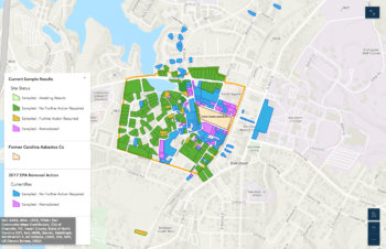
This screen shot shows past remediation activities in 2016/17 in purple and blue and current activities in green and orange.
Q. Is it too late to get sampling done?
A. (Angela Miller) It is not too late. If you are in that area – all you have to do is just contact me. (678-575-8132- [email protected]). We can get that scheduled. We will try to get that sampling done while we are out there. Our emphasis is the removal action – getting that taken care of, but we will sample properties.
(Chris Tripp) The main focus of the work that EPA is performing now is more geared toward the removal. Over the past year we have focused our efforts the best we could on getting permission and soil-sampling access from property owners in the community. Think we did pretty good with that – with 130-something properties sampled. But, ideally the sooner we could get the property owners reaching out to us – to provide access to their property – to provide soil sampling, the sooner the better. It takes some time to get those results back. And the sooner we get those results back to know if there are any additional properties that need to be included in what we anticipate to do the removal work on right now.
Q. (small talk between questioner and Angela) Is it possible to expand the map on the screen?
A. I tried that one time. So as Chris had mentioned, there is the live map in the “Story Map.” You can zoom in. If you have any trouble getting to that, just let me know and I will be happy to help you with that. [Note: questioner is most interested in where the properties are located, where this round of cleanup will be taking place.]
This time we have gone a little bit further. Last time we were right around the mill. This time we are on Mock Circle, Mock Road, Crane, and we have one on Potts.
That map on “Story Maps” is live and you will be able to zoom in and see the properties a lot better.
Q. I had my property done in 2017 but wonder if my property is still “non-detect” on Sloan Street.
A. The primary source of this material was the waste that was transported there as fill, and that was removed. So, we wouldn’t anticipate any significant amount that was blowing in from somewhere else. You should still be good.
Q. What risk is there to homes and owners remaining on site getting contaminated from their site? [What’s the risk if the homeowner wants to remain at home while the work is done?]
A. That’s going to be low risk. Angela showed the pictures of the things that will be going on. There are dust control measures in place. It is the inhalation of the stuff that is the health concern. So, we are minimizing dust. We will only be there between 2 and 3 days at the most – unless something unusual comes up. We make the offer to move people out. (providing hotel accommodations at no cost to the homeowner) You can come and go as you please, so you are not tripping over workers. . . We like to make the offer to put you up someplace while it is happening. So that nothing can go wrong, as far as your ability to come and go from your home. We will have heavy equipment going on, as well, and there are some general health and safety issues related to that. We aren’t concerned for this stuff causing threats to you while you are inside your home. We are making sure that the dust stays low. We are doing air monitoring to make sure that our dust control measures are working. So really, it is the coming and going when there is heavy equipment in your yard that is the biggest issue. If you prefer to stay in your home, that is something that we respect and we will work around you to make sure we can do that safely.
Angela – I do have some elderly residents who want to stay at home. And we are going to work around them, work around their doctor’s appointments, etc.
Tim – our primary concerns are the health and safety issues. The heavy equipment operating in the yards.
Angela – We don’t want to get in your way, and don’t want you to get into ours. We want to get the job done.
Q. How is the inside of the house protected during the remediation?
A. (Tim) I think we talked about that. It is protected by – your house is closed. We are limiting dust, and that is how it would be transported in. We are doing everything we can to minimize dust. We are keeping things wet so that there is not dust blowing around. We are using air monitoring – because we also need to protect our folks who are working out there. We are keeping dust down.
Angela – yes, that’s the thing I want to point out. We want to protect the community, but we also want to protect our workers, too – workers who are right in it. So we are taking all of these measures to make sure they are protected when they are right in it. So we certainly are making sure we are protecting our people, as well.

Charlotte Water’s project continues – with impacts to travel in and around Depot and Sloan. Work will move toward Beaty in coming weeks.
Q. What are the dangers to our water, as the Sloan Street water line improvements are in process? Daily we see the removal of the possible hazardous waste – the possible hazardous materials.
A. (Doug Wright) I can try to answer that for Charlotte Water. The water system that conveys drinking water to your house is a sealed system, and the water that is conveyed into your house via that sealed system is treated. So, there is not the possibility for those materials to migrate from the soil into that system. The systems are separate. Charlotte Water is following a similar process to remove the asbestos that they need to remove – just to do their water project. They are doing a similar process that the EPA will be doing. All those safeguards are in place for their workers and for the neighborhood. There is not a way for the materials in the soil to migrate into a seal pipe system that delivers water to your house.
Q. Does EPA expect to remove soil at a deeper depth at Roosevelt Wilson Park, given the significant outdoor use by children?
A. We have sampled through the park area, and the areas where we have discovered issues – we, the EPA, plan to do an average of about a foot of depth. If we come across areas where we come across visible pockets of more asbestos contaminated material – we’ll continue to excavate in those areas. The plan is also to work closely with the Town of Davidson, too – because they have some development plans for the park [note: a sensory garden is planned in one area]. We would like to ensure that the areas where they are planning to put anything in, that it would be safe to do so.
Q. If someone is to test positive, who should they contact?
A. [Angela – I’m assuming they mean if they test positive for asbestos] So if we have sampled your property, and your test results are positive at the levels we have set – we are the ones who are contacting you.
(Tim) If you are talking about yourself, if this a health question about your own health – work with your doctor.
Q. Was the creek bed off of Roosevelt Wilson Park tested?
A. (Tim) Yes, we talked about that earlier. I believe we tested the creek and the lake in 2017. Miguel – correct me if I am wrong. And we didn’t see any asbestos in the lake or creek.
(Miguel) Yes, that is correct. We tested the sediment in 2017 and it tested negative.
Q. Is there anything else that local citizens can do to ensure the success of this second emergency removal effort?
A. You could help us getting the word out. If there is a property that hasn’t been sampled, and you know that person – encourage them to give access so we can sample. If you would just help us spread the word. Sometimes information that is out there can get misconstrued, but if there is anyone who has any questions – just call. And we can help them at any time. Cell phone. Email.
(Chris Tripp) And another helpful reminder is just all the online resources available: local, state, and EPA. And we have the Story Map, that has pretty good information there.
Q. How deep is the new soil?
A. (Courtney Swanson) We are excavating in most places to a depth of about 6 inches. If we see observable asbestos containing material, we will dig further. And the excavated areas we backfill to their original surface level. We will put back as much as we take out is the short answer.
(Chris Tripp) Some areas we will go deeper – just because of the excavator bucket.
Q. Are there any longer-term limitations or remediation needed if some neighborhood-led revitalizations were done in the future?
A. (Doug Wright) Any work that takes place in the neighborhood in the future than includes excavation to a deep depth – such as the Charlotte Water project – this will be a consideration. And the Town will be putting some things in place with our permitting process that will flag these potential basement excavations, somebody building a pool, etc. So there will be an awareness out there, if that does happen in the future. We are already doing that with any utility work that’s taking place in the area and with any town projects in the area.
Q. Could there be asbestos under foundations of homes in the area? I recognize that the foundation is like a cap, but what if homeowners allowed house access. Could you do an air sampling in the house during remediation?
A. Yes, it is possible that there could be asbestos under the foundation. You are correct in that the foundation is acting as a cap and preventing exposure to that asbestos. For reasons that we have addressed previously, we can’t do indoor air sampling. If we are digging a yard we will have air sampling stations set up around where we are digging outside – that’s really where the risk would come from – would be us disturbing the asbestos fibers in the soil and those becoming airborne. For that reason – we do all the air sampling, and the soil-wetting that Tim mentioned earlier.
Q. Can you explain the differences in colors in the online maps that track progress in blue, green, purple or yellow?
A. There should be a legend with each map that explains each color. [note on the StoryMaps site, the legend is visible if you click on the blue circle with bullets inside on the lower left-hand corner]
Q. Not sure what you are talking about – story board?
A. It is called a “Story Map,” (and this is a site created specifically for the Davidson asbestos site). It has historical information, and information from when EPA came out in the first place (2016/17), and what we did then and what we are doing now. It has that map that we keep referring to. It is called a “Story Map.”
Q. Why are you using one map here, and there is another map there?
A. (Tim Frederick) We aren’t showing different things. There’s not anything shady or untoward about the maps. There are just different maps that we are using. The map on the “Story Map” is live and it is updated with the real time information from our maps. All of the maps have legends. If anything is unclear – just let us know and we can work to fix that.
(Angela) The purpose of this meeting was to provide an update on the removal, so I just used a simple map to show the areas that require further action. That’s why I chose that map.
Q. WFAE, NPR affiliate, is using the term “Asbestos Town” promoting their 3-part series of these issues. Besides the site being commercially developed, is there a clearance, a “clean bill of health” that Davidson can get so it is not labeled as “Asbestos Town” or that West Side is not labeled?
A. (Tim Frederick) The short answer is that we can show what we have done. We can show that we have removed asbestos where we found it. I don’t think that we can ever say that we know where 100% of it is, and that 100% is gone. We are doing our absolute best to find it where it is and remove it – and that’s what we can do. And when we are done, we will show that the work has been completed.
(Chris Tripp) And as far as the label of that from NPR, we don’t really have any control over the reports they put out. I don’t know where they came up with “Asbestos Town.” I would reach out to the NPR contact – David Boraks on that one if there is any sensitivity to language used in the reporting. I would reach out to David Boraks on that one.
(Miguel Alvalle) I would like to add that when EPA is done with their work on each of those parcels – those owners are going to receive a letter saying that their parcel has been remediated. So each of those owners will get notification saying that your site has been cleaned up. So that will provide some closure for those properties.
Q. Do you happen to know if the remediation work on Sloan Street is complete – meaning Charlotte Water ready to start their work.
A. (Doug Wright) The remediation work is being conducted by Charlotte Water on Sloan Street is part of their work. I don’t believe that they are done with asbestos removal just yet – I don’t think. We usually have a construction meeting today, but we didn’t have one. I’ll check and see on that schedule, but it is Charlotte Water – their contractor – doing the remediation. When the remediation work is done, they will begin working on the water line.
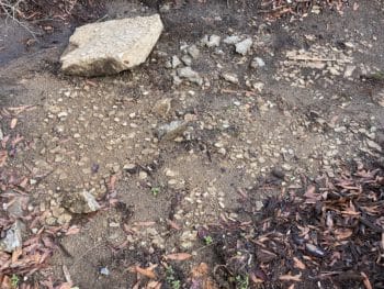
This photo shows the example of what is visible when asbestos was used as fill. When broken concrete blocks were removed in front of a home it was clearly evident that small pieces of broken tiles had been included in the fill under the original blocks. The pieces are visible on the ground and embedded on the bottom of the broken concrete.
Q. How many properties were tested in the green (a reference to one of the maps)?
A. (Angela pulled up a slide with details) As you can see we sampled 136 parcels this go round.
Q. How are you reaching out to residents – hand-delivered flyers, electronically, letters?
A. To obtain access, we sent out letters. Then we followed up. We did some door hangers. Remember, we were in the middle of the pandemic and everything was shut down. So, the door hangers were much later. We got some phone numbers, and I reached out making some phone calls. The very first virtual public meeting we had (July 15) was very helpful in allowing us to obtain more access. We have literally tried to be very creative as to how we reached out to the people because normally in a removal – we would be going door-to-door. But, we were in the middle of a pandemic, and everything was shut down. We were doing everything that we could to get in touch with people. Once they gave us access, we had phone numbers and email addresses and we were able to stay in contact with the people.
Q. Can additional properties be tested at this point?
A. We talked about that earlier. Yes. If you are in the expanded area – you can be tested while we are here. And like Chris said, make sure you do it sooner than later. Because at some point we will be done. It takes time to sample, and we have to get all that done. We have to get all that scheduled, and that takes time.
Q. For those that tested positive in 2017, are we now in the process of removing the soil?
A. If your property tested positive for asbestos contamination – we removed it. It is done.
(Chris Tripp) Yes, if it was tested previously, that work has already been done back in 2017.
[Note – Angela recognized the resident and confirmed that the remediation was done on her property.]
Comment – a resident who had remediation done in 2017 said that he was relocated during the process and that it was “super easy and didn’t cost their family anything.”
Yes. We pay for your hotel and all of that. It is an inconvenience to pick up your family and move for a couple of days, but we try to make it as comfortable as possible. It is a nice hotel – we are using the Residence Inn in Huntersville. There’s a nice size refrigerator, and there is a living room area – so you don’t feel like you are just sitting in your room on your bed for 3 days. . . We try to take care of you while we are cleaning up your yard.
Q. In the review of the Town of Davidson web page, [note: there is some misunderstanding as this question is read] We have requested this 4-year review with no success. We have tried via Freedom of Information. . .
Doug Wright – not sure what the person is asking, and suggest they reach out directly to me or to Amanda Preston – the Town’s public information officer so we can answer it.
Q. In the review of the web page map, the color codes are blue, green, purple, and orange – a dark and light yellow was in Angela’s slide. Please explain.
A. The slide presented in tonight’s presentation had light yellow to show properties where we need access.
(Miguel) As Chris referred to earlier, the darker yellow properties were already tested and are also part of right of way parcels. Charlotte Water and NCDOT – where they had some samples in the right of way and had some detects. Chris went back out to see if there was something the EPA could do.
(Chris Tripp) Yeh. That was just to track right of way areas like Miguel said. We wanted to make sure that where they had found something in their sampling – that at the surface there were no issues – everything came back okay.
I don’t know if anyone has the Story Map pulled up that we can just change the content of what we are displaying to it – real quick. I have it on mine. I could show you the better map – just because a lot of that was addressed in 2017.
[cross talk as they stop sharing one screen to shift to another screen with the Story Map]
Now the conversation shifts to a specific description of what is visible on the Story Map site.
- Blue properties were sampled in 2016/17 – no further action required
- Purple were properties that were sampled and remediated in 2017
- Green properties were sampled in 2020 – no further action required
- Orange properties were sampled in 2020 – and require remediation
(Chris Tripp) So just being able to show this – hopefully, the helps to do away with the confusion.
(Miguel) So if you are looking at this map with the combined data from 2020 and the work in 2017 – if the properties are green or blue, those properties were sampled and were non-detect. Anything that is purple or orange came back and required removal action. Purple has already been removed in 2017. And the orange is what will be done in 2021.
Q. What are the Superfund file records? And how do you access?
A. So, our Superfund files are found on our laser-fiche web site, and we can provide that link as well. In the laser-fiche files you can find the brownfields site files, as well as the inactive sites branch – which is the superfund portion of the site. And there are two sites: the property site – which is the Carolina Asbestos Company property and the Davidson asbestos – which is the general area around the property. There are two sites, and then there is the brownfields portion of the one site.
Q. You mentioned that Charlotte Water is taking care of their asbestos removal for the water main project. So there was a home that had windows knocked out, and the home surrounded with red danger tape and asbestos sign. Workers had Tyvek suits on. Do you know if that posed a threat to the homeowners next door?
A. (Doug Wright) I can talk about that. That house is 335 Sloan Street – which the town owns. We bought the house because of an upcoming road project, roundabout at the intersection of Beaty and Griffith Street. We are moving that house to Crane Street. That house is a contributing structure to our historic district – so we are going to physically move that house to a lot that the town owns on Crane Street. As part of moving that house we had an asbestos materials containment assessment done of the interior of the house. And there are some floor tile and other minor materials in the house that did contain asbestos. My understanding is that is very typical of houses this age. So, the town hired a certified asbestos contractor to remove those asbestos-containing materials from the house prior to the house being moved. We anticipate moving that house in April. The type of asbestos material that is on the interior of the house is not the same thing that the EPA is removing on their project here or that Charlotte Water is dealing with in the road. It is about materials used on the interior of houses of this vintage like floor tile.
Q. The West Side of Davidson will likely have a non-gentrifying revitalization sometime sooner rather than later. Is it correct that your previous answer means that the asbestos issues – even with the remediation of specific homes – could have a future cost impact or design limitation?
A. (Doug Wright) It is fair to say that houses in the vicinity of the old mill, this will be some consideration. It depends on what some owners want to do with their property – at what depth they will be excavating. It is reasonable to think that this will be of some consideration for those owners in the future.
Comment: Charlotte Water commented – saying that there is a little bit more to be removed along Sloan.
FYI Comment: Smithville – an African-American neighborhood in Cornelius – was once labeled “Germ Town” in the mid-1960s by a Charlotte newspaper. It was not helpful.
Q. Because I wasn’t notified of those activities by Charlotte Water and talked to them personally about my concern about it becoming airborne. And the work was being done right in front of my house.
A. (Doug) If anybody has any concerns about the Charlotte Water project – while it is not the topic tonight – absolutely, I would be more than happy to help with that. Just reach out to me after the meeting. We will work on that.
Here’s another comment from Charlotte Water – for the area in the roadway where we are performing remediation – we are wetting the soil and have air monitoring in place. Charlotte Water isn’t performing any remediation on structures.
We have to thank you. This has been very informative and they are happy to help deliver door hangers, flyers to the homes that are in limbo.
Angela – Thank you so much. We had Doug out there walking – I think it was 100 degrees out there the day you were delivering the flyers. Remember, we were in pandemic and everything was shut down and we couldn’t travel. So, Doug said “I’ll go.” And we had some EPA staff who live in North Carolina help.
I don’t think that there are – I think that’s it. Looks like a lot of people very interested in the Story Map. A lot of people are commenting and complimenting.
A lot of hard work went into that Story Map. It is a great resource. It is on EPA, DEQ, and Town of Davidson – on everybody’s web page.
(Chris Tripp) Thanks to everybody for working on it. I’m glad it’s out there as a resource.
(Angela) It is a great resource. And like Chris said earlier – It is live. As the work goes on, as it continues – the map will change. But there is always a legend to the map. If you have any questions interpreting it, just reach out at any time.
(Chris Tripp) As the properties are cleaned up, the color will change from orange to another color. And then if any other properties are sampled, those will change, as well.
(Doug Wright) I just wanted to reiterate, to follow up on something that Tim mentioned. When the testing area was expanded, I don’t think anybody knew exactly what we would find there. And it looks like to me, the results here are very encouraging. The testing area expanded to the West – it took in the newer houses that were built later on Westside Terrace, Mallard Court, Cardinal Court, etc – and we just haven’t found anything over there in that area. I think that’s very encouraging. As a result of expanding testing that residents requested – and that these folks have done.
(Angela) If we don’t have any more questions. . .thank you so much for taking the time out to attend these meetings.
More than likely, we will have one more meeting after we complete the removal – we will come back and give you all the details. Like we did the last time we finished in October 2017.
Town of Davidson – I can’t thank you enough for always hosting us on these virtual meetings – thank you so much Doug and Betsy.
(Tim) There’s a late-breaking question.
Q. Will the homes near Roosevelt Wilson Park during remediation be impacted? Will people be relocated?
A. There are a couple homes – a couple that I’m going to offer relocation. [note: Angela recognizes the questioner and says that they will not be one of those and asks the person to call her personally to discuss.] There are a couple of home that we will offer relocation.
(Angela) Thanks again for your time and your great questions! Please contact us if you have any questions that we didn’t explain clearly enough. If there is something we didn’t answer – just reach out to us – we are happy to help.
Throughout the meeting, residents were encouraged to reach out to EPA or NCDEQ representatives with further questions. That contact information is provided below.
Angela Miller, Environmental Protection Agency (EPA)
Community Involvement Coordinator
678-575-8132
Chris Tripp, EPA
On-Scene Coordinator
404-562-8745
Courtney Swanson, EPA
On-Scene Coordinator
404-562-8753
Miguel Alvalle, N.C. Department of Environmental Quality (NCDEQ)
704-663-1699
Laura Leonard, NCDEQ Public Information Officer
919-280-0544
Doug Wright, Town of Davidson
Project Manager
704-940-9625